-

Flood focus
Feature story08 October 2017Autumn and winter rain caused damaging floods and slips across New Zealand, yet again. Susan Pepperell investigates the nation's evolving skill in avoiding and coping with water. -

A wave of hazard research
Feature story05 October 2017It is well known that earthquakes can trigger tsunami but they can also be caused by landslides – with devastating effects. -

On-call forecasting helps fight fires
Feature story05 October 2017For the past year, NIWA’s meteorologists have been on call to provide real-time, comprehensive information about weather patterns that may accelerate a fire. -

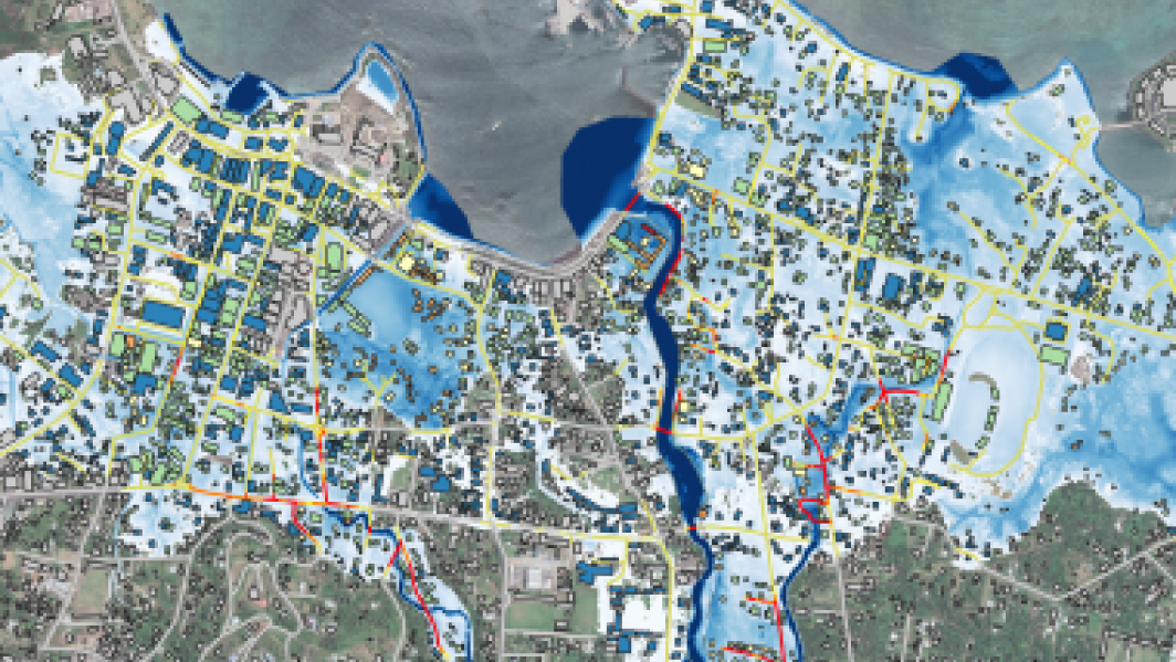
Calculated risk
Feature story13 June 2017Imagine if you could foresee what would happen to your home in a severe flood or tsunami, and then work out how to prevent or reduce the impact before any such event occurred. -

NIWA invests $18 million in New Zealand’s future
Media release08 June 2017NIWA is placing the future of New Zealanders at the heart of its operation by investing in new supercomputers that will significantly enhance scientists’ abilities to solve crucial issues facing the country. -

Extreme weather - heavy rainfall
Education ResourceHeavy rainfall is one of the most frequent and widespread severe weather hazards to affect New Zealand. -
Extreme weather - winds and tornadoes
Education ResourceDue to its position in the 'Roaring Forties', a belt of strong winds in the Southern Hemisphere which generally occur between the latitudes of 40 and 49 degrees, as well as its small size, New Zealand is a windy country. -
Risk and vulnerability
Education ResourceRisks from natural hazards are part of every day life for New Zealanders. -

Coastal storm inundation
Education ResourceNew Zealand has low-lying coastal areas that are vulnerable to inundation (flooding) by the sea. -
Sea level rise and coastal inundation mapping of the Avon-Heathcote Estuary, Christchurch
Urban Infrastructure and the Built Environment Toolbox case study -
Flood modelling of the Buller River, Westport
Urban Infrastructure and the Built Environment Toolbox case study -

Common climate and weather terms
Education ResourceA glossary of common climate change and meteorological terms.